Effects of sea level rise on maritime forest dieback
Project Title: Effects of sea level rise on maritime forest dieback
Duration: July 2020-July 2021
Funding Source(s): NSF
Lead Investigator: Elizabeth Watson
Affiliation: Drexel University and the Academy of Natural Sciences
Email: elizabeth.b.watson@gmail.com
Project Description: This project will analyze groundwater patterns, salinity, and plant stress using mapping of near-infra spectral indices
to address knowledge gaps in our understanding of the impacts of sea level rise to maritime forests. We are focusing
on understanding the proximate causes of forest dieback by building robust and complementary geospatial datasets
focusing on key hydrologic factors and plant stress indicators. This project also involves study sites in New Jersey
and New York and aims to focus on identifying whether salinity or flooding thresholds exist in terms of driving
forest die-off as well as how local factors such as geology and sediment permeability alter these factors.
Evaluating the Impact of Hydrologic Alterations on Salt Marsh Sustainability in a Changing Climate
Project Title: Evaluating the Impact of Hydrologic Alterations on Salt Marsh Sustainability in a Changing Climate
Project Partners: Cape Cod Mosquito Control Project, Louisiana State University, National Park Service, United States Fish and Wildlife Service, Rachel Carson National Wildlife Refuge, United States Geologic Survey, Waquoit Bay National Estuarine Research Reserve, Woods Hole Oceanographic Institution
Coastal managers are faced with the challenge of managing marsh hydrology in a way that meets human health needs, optimizes ecosystem services, and supports sustainability. In New England this includes accounting for the effects of ditches that were dug decades ago in 90% of the region’s salt marshes.
Ditches increase marsh drainage and reduce the spatial extent of shallow pools that may represent physical loss of buried soil carbon. However, efficient drainage may reduce the long-term sustainability of marshes by altering below ground biogeochemical and physical processes in a way that results in subsidence and lowered marsh elevation. Managers, restoration practitioners, and scientists at the Waquoit Bay National Estuarine Research Reserve, Woods Hole Oceanographic Institution, U.S. Geological Survey, U.S. Fish and Wildlife Service, National Park Service, and the Cape Cod Mosquito Control Project have expressed a need to understand the tradeoffs of hydrologic management strategies (i.e., ditch remediation, density, maintenance) and identify actions that will achieve user-specified outcomes— such as drainage, maintaining elevation, and carbon burial.
Products:
FACT SHEET: Project Overview
WHOI Website: Marsh Sustainability & Hydrology
Marshes, Mosquitos & Sea Level Rise-Oceanus Magazine Video Link
Marsh Sustainability and Hydrology (MSH) Project Webinar
October 2020
The MSH project is a collaborative research effort involving partners from the University of Georgia, Woods Hole Oceanographic Institution, Louisiana State University, United States Geological Survey, Cape Cod Mosquito Control, US Fish and Wildlife Service, National Park Service and the Waquoit Bay National Estuarine Research Reserve.
Coastal resource managers are tasked with making decisions that simultaneously address the welfare of local communities and the sustainability of salt marshes and the valuable ecosystem services they support. In New England, anthropogenic ditches were dug to reduce shallow ponds on the marsh platform where mosquitos breed, although this may have led to unintended consequences such as lower elevations and increased susceptibility to sea-level rise. In order to evaluate the net impacts of ditching to carbon storage and elevation resilience, we collected cores from the ditched and unditched sections of Great Barnstable Marsh (MA, USA) and measured and compared accretion rates, soil properties, soil organic carbon and ages to determine impact of ditching on marsh sustainability to sea level rise. A geomorphic model calibrated with field data was used to develop a decision support tool to help managers assess impact of different management strategies on salt marsh sustainability and ecosystem service delivery.
To view the workshop presentations please go to: Marsh Sustainability and Hydrology Project Webinar Presentation Videos
MSH Team Members:
Amanda Spivak, Principal Investigator, University of Georgia
Sheron Luk, PhD Student, Woods Hole Oceanographic Institution
Meagan Eagle, United States Geological Survey
Gabrielle Sakolsky, Director, Cape Cod Mosquito Control
Susan Adamovich, US Fish and Wildlife Service
Giulio Mariotti, Louisiana State University
Megan Tyrrell, Research Coordinator, Waquoit Bay National Estuarine Research Reserve
Tonna-Marie Surgeon Rogers, Director, Waquoit Bay National Estuarine Research Reserve
Late Holocene Marine Transgression and the Drowning of a Coastal Forest: Lessons from the Past
PI: Chris Maio, UMASS-Boston, PhD Candidate.
Advisor: Allan Gontz, UMASS-Boston
Funding: UMASS-Boston, Geological Society of America Research Award, collaborative in-kind-WBNERR
My research looks at coastal changes that have occurred in response to sea-level rise and storminess during the past 4000 years. I use a variety of methods including sediment core analysis, ground penetrating radar, GIS, and radiocarbon dating. Learning about how the Waquoit estuarine system responded to past sea level-rise and storminess will provide needed context for understanding and anticipating future changes.
An ancient red cedar forest was first revealed after a series of storms in 2010 resulted in significant erosion along South Cape Beach revealing 111 subfossil stumps along the beach and into the water. Thirteen stumps were radiocarbon dated and ranged in age from ~413-1200 years old. We assume this age represents the time at which the ancient trees were drowned by marine waters. Shoreline change analysis showed that between 1846 and 2008, the shoreline fronting the paleoforest retreated landward by 70 m at a long-term rate of 0.43 m/yr. 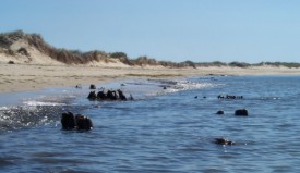
Sediment cores were analyzed to determine storm and sea level history. Radiocarbon dates of bivalve microfossils indicate that Waquoit Bay was first inundated by marine waters approximately 3600 years ago. The ongoing research will help decipher the relationship between sea-level rise, storminess, and the inundation of terrestrial ecosystems and will help to illuminate what caused the drowning of the South Cape Beach paleoforest.