Habitat, Animals, and Plants

Habitat Mapping
Click here for map showing change in salt marsh pool extent (2004-2012) in northern portion of Sage Lot Pond, Mashpee, MA.
A preliminary conclusion from analyses of change in pool area between 2004 and 2012 indicates that the amount of salt marsh surface that is classified as pool (no emergent vegetation) has increased by approximately 0.4 acres per year. These analyses were generated by Nate Herrold, NOAA Office of Coastal Management, with all data provided by WBNERR. The apparent expansion of pool habitat at WBNERR was partial impetus for our participation in the NERRS Science Collaborative Project examining the efficacy of thin layer placement (also known as sediment augmentation) as a restoration technique for marshes that are losing cover of emergent vegetation (e.g. salt marsh cordgrass and similar vascular plants) to open water.
Animals
Endangered Shorebirds: Protecting rare shorebirds is a collaborative effort from various biologists, private organizations, state agencies, beach managers, and volunteers. The Waquoit Bay Reserve has participated in rare shorebird monitoring and conservation efforts since 1990. WBNERR monitors South Cape Beach and Washburn Island, which are part of the Reserve, and also private nesting areas at New Seabury Beach and the Menauhant Yacht Club Beach. Population monitoring serves as an integral aspect of recovery efforts for an array of shorebirds. It allows wildlife managers to identify limiting factors, assess effects of management actions and regulatory protection, and track progress toward recovery. Actively protecting piping plovers (Threatened) and least terns (special concern) at WBNERR also protects the beach, dune and marsh habitats for many species of wildlife including a wide variety of shorebirds and rare tern species that use the barrier beach and coastal salt marsh system to feed, nest or stopover during spring/fall migrations. Arctic, Common, Roseate and Least Terns rest on our beaches and forage in the waters off South Cape and Washburn Island. Nearby Buzzards Bay, hosts the largest Federally Endangered roseate tern colony in North America.

Horseshoe Crab spawning survey: Horseshoe crabs are counted in a known spawning area during the full and new-moon high tides in May and June as part of a regional effort to characterize the spawning population and to summarize a relative spawning index over time for the species. The MA Division of Marine Fisheries compiles data from Massachusetts to assess trends in the spawning population and inform management decisions.
Breeding birds: Birds are commonly used as sensitive environmental indicators. While, birds are only one of several types of organisms that inhabit salt marshes, they can yield insight that may be overlooked by studying only plants, invertebrates or fish. In 2000, the Reserve launched a volunteer-based effort to monitor the populations of breeding birds in three areas of the Reserve; the Quashnet River, Abigail’s Brook and Sage Lot Pond. Monitoring the population of breeding birds over time can give managers information on changes in vegetation, prey abundance, predation pressure, and changing climate.
Osprey: Like many raptors, this once-endangered bird has made a spectacular comeback since banning the pesticide, DDT. The Waquoit Bay Reserve has documented a total of 37 osprey nest sites in the areas around Waquoit Bay. The Reserve has participated in monitoring and data collection in collaboration with the Mass Audubon. Additional information and resources can be found at https://www.massaudubon.org/learn/nature-wildlife/birds/ospreys.

Photo by J. Harrison
New England Cottontail rabbit: This native species is separate from the introduced Eastern Cottontail rabbits typically seen in open areas. New England Cottontails need dense underbrush to survive. As forests mature and shade out brush, or land is cleared for housing, this habitat has become increasingly rare, resulting in a disappearance of these rabbits from 86% of their former range. In an effort to keep it off the endangered species list, US Fish and Wildlife Service is documenting species occurrence, population estimates, and recovery efforts. Cape Cod and especially Mashpee (including Reserve land at South Cape Beach) contain some of the largest populations of the species in New England. Monitoring consists of trapping, tagging, collaring, and tracking individual rabbits. It also includes pellet collection and DNA analysis for species identification. Field work is done primarily in the winter. (http://www.fws.gov/northeast/indepth/rabbit/index.html).
A New England Cottontail success story highlighting three Mashpee NEC projects can be found on the Massachusetts Natural Resource Conservation Service website. Mashpee River Reservation (TTOR), Carl Monge Sanctuary (Orenda Wildlife Land Trust) and the Mashpee Wampanoag Tribe: https://www.nrcs.usda.gov/wps/portal/nrcs/detail/nh/technical/ecoscience/threat/?cid=stelprdb1086003.
Trout: Brook trout are the only trout native to eastern North America and are considered an indicator species because they are sensitive to change in the environment. Historically very common in this region, the brook trout is now classified as “reduced”, “greatly reduced” or “extirpated” from its original home waters in eastern Massachusetts, which is indicative of the degree of modification to their original habitats. Together with MA Fish and Game and Trout Unlimited, we track movement of tagged fish throughout the watershed. Animal tagging studies help us understand individual movement behaviors, the size of home ranges, migration patterns, habitat usage, and population characteristics. Understanding these factors can inform conservation decisions pertaining to many species, but is particularly important when dealing with anadromous fish, such as sea-run brook trout, because of their complex life histories.
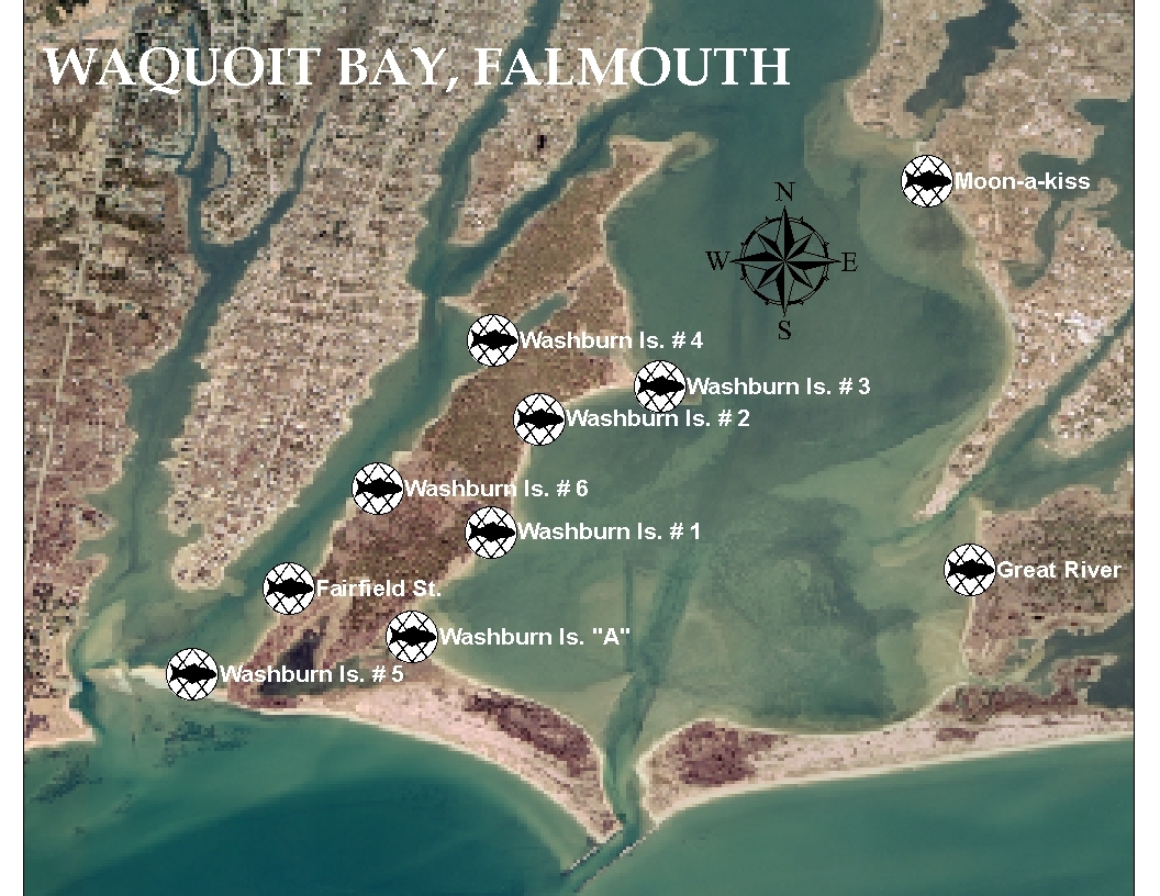 Fish survey: The Massachusetts Division of Marine Fisheries (MDMF) has carried out an annual beach seine survey in six Cape Cod estuaries (including Waquoit Bay) since the mid-1970s with the primary mission of assessing the young-of-the-year winter flounder population. The results are used to assess the status of this commercially and recreationally valuable species. While carrying out this regular survey, MDMF has also recorded detailed data on a number of other species including Blue Crab and Green Crab. Interestingly this database spans a period of notable habitat quality decline, particularly a major reduction in eelgrass, within most of these Cape Cod estuaries. The dataset represents the longest, most detailed, and most rigorously maintained biological record of estuarine species for Cape Cod.
See MA DMF’s resource assessment project page to find out more about this sampling program.
PLANTS
In addition to the SWMP SAV survey, the Reserve monitors two rare plant species. Agalinis acuta (sandplain gerardia) and Liatris borealis (New England blazing star) are monitored annually with help from the Massachusetts Natural Heritage/ Endangered Species Program. Agalinis, with fewer than 15 known sites, is on the Federal endangered species list and Liatris is a state-listed plant of special concern: https://www.mass.gov/info-details/list-of-endangered-threatened-and-special-concern-species#plants.